AFTER several heatwaves and an unusually wet month of May, the weather in Spain will continue to be unusual from the start of August onwards, thanks to some surprising falls in temperature.
According to the Aemet state weather service, the mercury will plummet in the north of the Iberian peninsula from Thursday onward, registering temperatures that are up to 10ºC below the norm for this time of year.
The fall will be thanks to the arrival of winds in the north and the northwest that will bring with them colder air than that expected in the rest of Spain.
The result will be temperatures barely breaking 20ºC in some cities on Friday, and lows of around 10ºC during the nighttime. The areas affected include Galicia, Cantabria and the Pyrenees, which could also see rainfall toward the end of the week.
Pamplona is another of the affected areas, with maximums of 23ºC forecast for Thursday compared to the usual 35ºC for this time of year.
The fall in temperatures, however, will be brief according to Aemet and the hot weather will soon return.
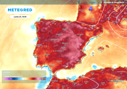
Today, Monday, is another day of very warm weather with highs of 34 to 36ºC in the south of the peninsula and the Canary Islands, and a scorching 40ºC in the Valle del Guadalquivir.
A very warm night awaits tonight, meanwhile, in areas such as Barcelona, Castellon, Valencia, Malaga and Palma de Mallorca, with the temperatures unlikely to fall below 25ºC.
Read more:
- Weather in Spain’s Andalucia: August arrives with warm air mass and tropical nights
- Alicante province experiencing the hottest July nights in the last 100 years
- Considerable drop in temperatures expected on Spain’s Costa del Sol before another weekend rise
Click here to read more Weather News from The Olive Press.