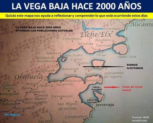
THE Vega Baja region is prone to flooding because it was once part of the Mediterranean Sea, a Roman-era map of the area shows.
The map from the Museo de Arqueología de Elche shows the Dolores, Catral, Almoradi and Algorfa municipalities were all underwater just centuries ago.
The aforementioned areas were some of the worst affected by the catastrophic flooding that has rocked the Costa Blanca over the last week.
Weather watching site MeteOrihuela published the map today explaining that the Vega Baja was ‘a gulf that existed south of Elche in Roman times’.
Sediment over the following centuries eventually silted up the shallow waters, providing a fertile environment for agriculture, according to MeteOrihuela.
The area’s history is retained in the name Baja (low), as it sits little higher than sea level – leaving it exposed to flooding from both east and west.
“Perhaps this map helps us to reflect and understand what has happened these days,” a statement from MeteOrihuela said.
The gota fría storm that caused seven fatalities saw record-breaking rains hit the Vega Baja – the city of Orihuela received nearly twice its annual rainfall when 400 l/m² fell in a two-day period.
The lowlands of the Vega Baja were the only destination for the floodwaters, leaving destruction and devastation in their wake.
READ MORE: Death toll reaches seven as body of Dutchman found near Dolores following deadly Costa Blanca floods
READ MORE: ‘Warming Mediterranean Sea’ was behind record-breaking rain, claims Alicante professor
Click here to read more Costa Blanca News from The Olive Press.